

In relation to our series upon the coral reef mapping in Australia we can report one further achievement. A new 3D map shows the underwater topography of the Flinders Reefs that lie around 230km offshore from Townsville in the North of Queensland, Australia. The initiative is triggered by Dr. Robin Beaman from James Cook University in Cairns. While large parts of Australian’s reefs were mapped by the Royal Australian Navy using their LADS airborne lidar bathymetry system, Dr. Beaman works together with the Germany based company EOMAP and takes advantage of optical satellite imagery from LANDSAT 8 to map considerable areas of shallow reefs that lack detailed maps. The high-resolution data allow to extract bathymetric information down to a depth of around 50m owing to the clear, sunlit water at these reefs.
“By refining the satellite data and merging it with existing data, I’ve produced 3D depth maps for these reefs and atolls. That gives us a much more detailed picture than was previously available” Dr. Beaman said.
The project focussed on the reefs and atolls within those waters of the Coral Sea that fall within Australia’s Exclusive Economic Zone, also called the Coral Sea marine Reserve.
“These are atolls that grew upwards from tilted continental blocks created when Gondwana was breaking up. The 3D images we now have of North and South Flinders Reefs are really stunning, showing classic atoll shapes with a shallow coral rim around a deeper lagoon. With this new 3D information we can now better predict where coral diversity is located around the edge of these reefs, because we know where we’re likely to find the shallow and deeper coral communities,” he said. – “That information will help marine researchers to plan future scientific expeditions, and it will help managers of the various conservation zones determine what other marine life they can expect to find there.”
Dr Beaman hopes the maps will be a valuable resource in the ongoing discussion as to what levels of protection should be given to different areas of the Coral Sea Marine Reserve.
More broadly, oceanographers could use the 3D data to more accurately model how oceanic currents move over and past these reefs before reaching the Great Barrier Reef.
EOMAP, which did the realization of mapping, resides in Munich. Its site can be found here.
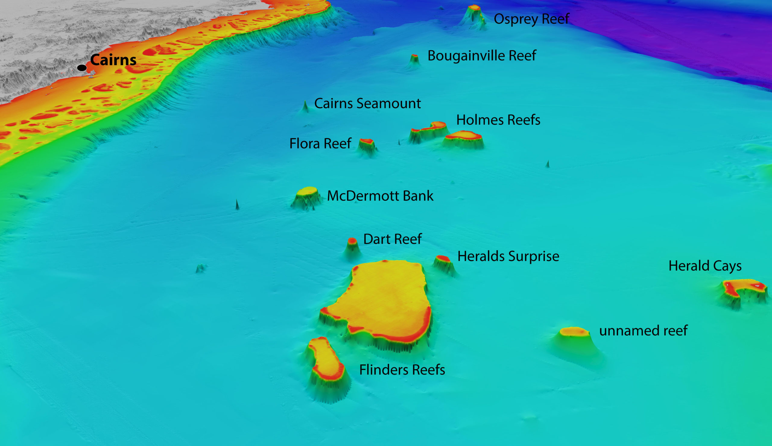
North-westerly view of the Coral Sea reefs towards Cairns. Depths are coloured red (shallow) to purple (deep), over a depth range of about 4000 metres. Exposed land is coloured grey. Source: Includes material © (2015) EOMAP. All rights reserved.
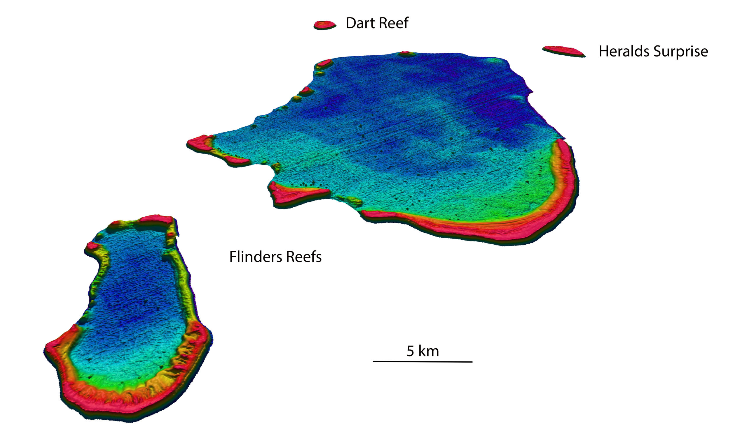
North-westerly view of the Flinders Reefs in the Coral Sea, about 230 km offshore from Townsville.
Depths are coloured red (shallow) to purple (deep), over a depth range of about 50 metres. Source: Bathymetry data © (2015) EOMAP Bathymetry

#


Next article

The Landsat program from USGS/NASA is certainly the most iconic Earth Observation program ever. Not only does it provide the longest continuous space-based record of Earth but the Landsat program also democratized access to satellite imagery, enabling researchers across the world to use latest satellite imagery for various Remote sensing and GIS studies. (Read more: Landsat 8 Captures dramatic details of the Earth; will push the Earth – Monitoring Envelope).
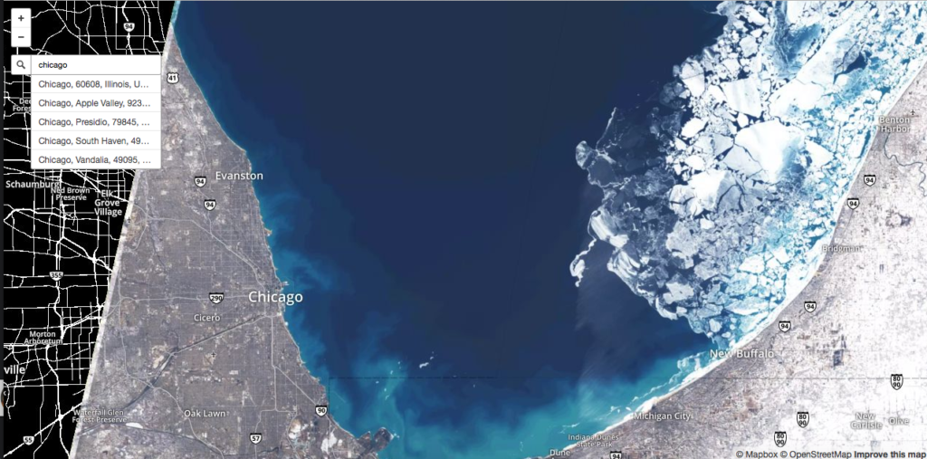
Although Landsat satellite imagery have been available for the public for a while now, we haven’t had a project that can be considered as the OpenSatelliteImagery project, well until now. Mapbox has changed that with Landsat-live, a geoawesome project that utilizes the latest Landsat 8 data is publicly available on Amazon Web Service via the Landsat on AWS Public Data Set.

Chicago March 11, 2015 (Landsat 8 imagery via Mapbox Landsat-live)
With every pixel captured within the past 32 days, Landsat-live features the freshest imagery possible around the entire planet. – Camilla Mahon, Mapbox blog
Finally, a project that lets us understand how the planet changes in weeks, instead of the picture perfect – sunny, green satellite imagery that we are so used to by now thanks to Google Earth and other similar projects. Mapbox‘s Landsat-live is going to help showcase the big gap between how we perceive the world in our maps with satellite imagery overlays and how it actually is. And of course, Mapbox choose to overlay the satellite imagery with OpenStreetMap data 🙂
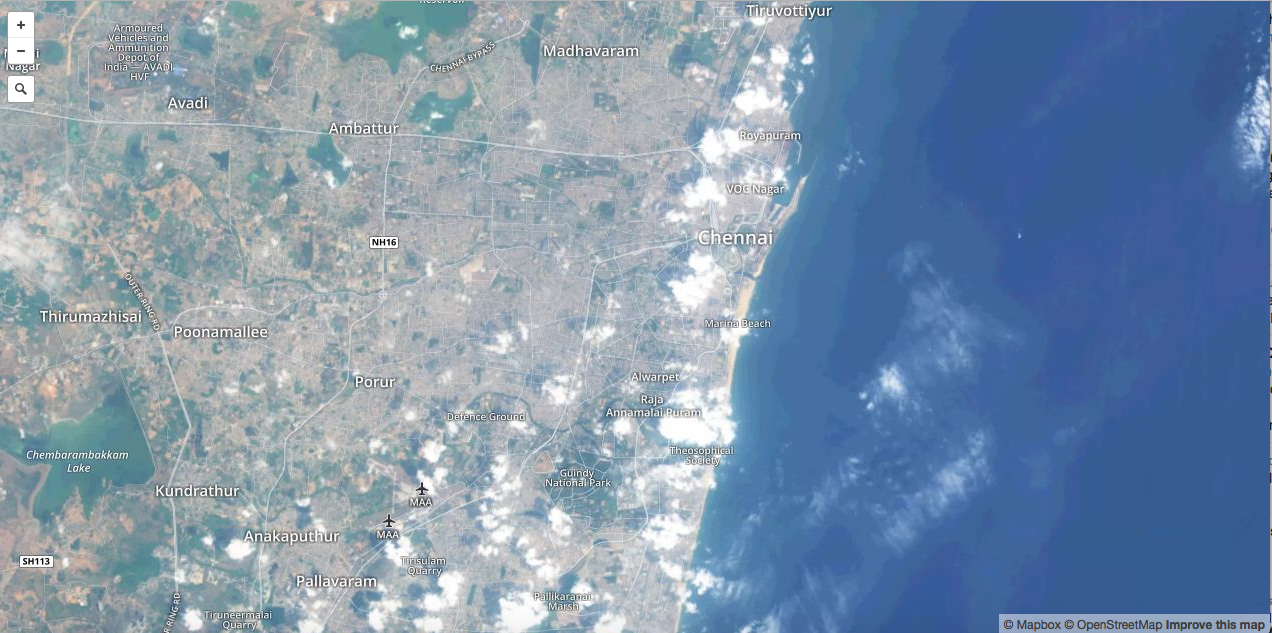
Chennai, India
With a 30 meter resolution, a 16 day revisit rate, and 10 multispectral bands, this imagery can be used to check the health of agricultural fields, the latest update on a natural disaster, or the progression of deforestation. – Camilla Mahon, Mapbox blog
Besides the Earth Observation projects that Landsat-live would make possible, I am sure it is not going to be long before someone decide to create the next Geoguessr with this project. Satguessr – the Landsat-live based Geography game! maybe we should 😉 Anyone interested in the idea? 🙂
Five years from now, real-time maps might be as ubiquitous as YouTube videos—but for now, they feel as futuristic as movies might have to Victorians. – Charlie Loyd, Mapbox to Citylabs
Mapbox’s Landsat-live project showcases the Landsat program in the kind of spotlight, it deserves.
P.S: @Mapbox: maybe you guys can think about adding a timeline functionality for the Landsat-live service! It would be all the awesome to see how things have changed in the last few satellite revisit periods.